Tinkers Creek
| Stretch: | Bedford Reservation |
| Difficulty: | Class III to IV low, IV to IV+ high (V) |
| Distance: | 0.6 (meat) or 4.25 miles |
| Flows: | 250+ cfs for the meat section. 450-1,000 for full run. Check out USGS's current flow gauge. |
| Gradient: | 165 fpm average (mi 0.7-1.3), 55 fpm average overall |
| Put-in: | Broadway Trailhead |
| Take-out: | Dunham Rd |
| Shuttle: | 4.5 miles, (10 minutes one-way) |
| Season: | Fall to Spring, rainfed, flashy |
| Written: | © 2022 |
I first saw this run when a friend of mine mentioned it with regarding a weekend he had up in Ohio getting this, Cuyahoga Falls, and West Falls on the Black River. I made note of those runs as they all looked great.
In 2020 we made plans to head up for the weekend of the Cuyahoga Falls Festival. But due to Covid 19 outbreak, the trip was canceled. Then in 2021 we went to Maine instead. Finally, in 2022 the plans worked out for us to finally head up this way, using the Cuyahoga Falls as an excuse to also visit the Cuyahoga Valley National Park as well. Regretfully though, with our need to ask for time off of work a few months in advance, we accidentally ended up being a week early to the falls festival when the dates for the festival were finally announced.
Upon our arrival, the area had just been hit by rain and Tinkers Creek was at a runnable but low 475 cfs. Through the day as we drove North and through the night, it fell though. We hoped that upon waking up the sprinkle of rain would bump it up to the minimum you need for a "meat of the river" lap. That starts below the falls and goes to the last of the major rapids, just a quarter mile downstream. This is runnable down to 250 and can be hiked for shuttle/laps. Where as to do the whole run 400 or even 450 is the locals low. Waking up though, we see the flow is 240. Too low even for the meat of the run. We decide to still head that way though just to take a look at it as with the bad weather we weren't going to have much else to do with the kids. To our luck, the rain did bump it and as we drove we saw it come up to 250... scouted, looked good enough, and then saw it was 300, fantastic! I put on. We played after my lap, letting Aster splash around in the puddles, and then went up for Diane's lap and by then it was 350! What luck! That is where it peaked for the day though, and by evening it was back below 250.
The run is a nice little creek, nice scenery, a few fun rapids, a stupid fun tunnel and slide, and depending on the flow, a 20' waterfall that does have some issues, but also can offer up a lot of fun. The rest of the run is easier, slides, mellow holes, and boogie. The bottom 3 miles of the run is in the National Park so that is also nice.
I also just want to give a shout out to Don Howdyshell who reached out when I posted on facebook and gave me all the beta I needed for hiking in to scout and for hiking out of the meat run, it wouldn't have been possible without those tips!
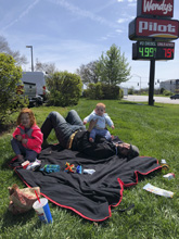
Note: For the life of us we can't find the point and shoot camera that we had with us in Ohio... did we lose it? This means that there is no pictures sadly of the rest of the run.
Mi 0.0:
- Warm Up (II to III). I will disclaim that we did not run this as we had minimum flow and put on below the falls. However we did look at it from Broadway Ave and from Union St. From what I saw it was class II-III and that fits with everything above and below the meat section being substantially easier.
- Great Falls (V). Easily visible from the Viaduct Park (like a 200 yard walk on a paved path). Scout right. I have seen video of two different lines, one is on the right hitting the left side of the slide to a bit of an autoboof. There was wood in the landing here our day and it just looked too low to have a clean launch. Apparently it is not deep in there so it was a no go. At higher flows you can also launch left of center off the full 20' of freefall. However, be aware there are rocks in the landing so you have to know where you want to land to land in the channel between them.
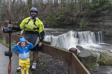
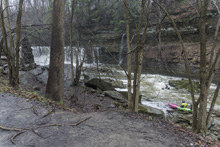
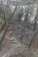
In Between (II+ to III-). Below the falls we launched in and got one little double drop with small holes.
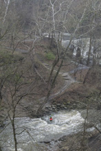
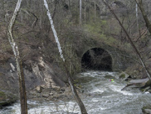
- Tunnel (IV- to IV). You will then be led to the Tunnel. At low flow there was a curling reactionary that you can just make out as you enter. I hit this left. I thought, "wow at high flows I bet that gets stout." But I have since watched video of higher water descents and it actually doesn't get bigger, and is easy to go right around. Below that, the tunnel bends left (gets dark in there for a few feet). You just don't want to be against the left wall, best is center or even right of center. The reason is is because as you exit the tunnel, you are accelerated onto a slide. The very far left 5 feet fall off left into a crack that isn't ideal at all. The rest accelerates down into a wave hole that isn't sticky but does have power to flip you into the eddy below. To scout the exit, you can go to the "Willis Picnic Area, Bedford Reservation" and walk the unmarked, but well used, trail that goes more or less along the train tracks and drops down to the river at the exit. It is maybe 200 yards, can be a little muddy and slippery when wet.
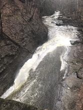
- Slide and Ledge (IV- to IV). I hoped out to scout this one as I was solo and not taking chances, but told Diane it was all good so for her laps she didn't have to. The main flow went down the left, but there were two trees hanging down into the flows that were passable but in play. This led me to look to the right of center slot for my entrance which was just a small ledge. Slack water then left to a slide that the flow dropped off the right side of into a good size hole. I think far left at higher flows would be mellow and just a low angle slide. It was too scrappy at the low flow so I went center driving left, to then boof the ledge back pointing right. Falling off the ledge far far right is a bit of a caldron so I bet that should be avoided at most flows. It is easy to scout as there is a trail just off the river level from the tunnel all the way down.
Tight Slotz (IV- to IV). AW only has two rapids named. I would have thought the slide and ledge I described above would be included, but it doesn't appear so as the first description seems to match this one. Or is Tight Slotz all one rapid below the tunnel but at the low flow we had they seemed to be different rapids, I don't know. Anyways, this one could be entered far left or could be entered by zagging right to left behind a boulder fence. The left did not have any eddies and I was solo, so I went right to get more visibility into the rapid before committing. It was clean, so I just cut behind one of the large boulders forming a fence and got back to the main flow. From there, it was a low angle slide into some small holes. The river then bent right and quickly got to Junkpile.
- Junkpile (III+ to IV-). There was some wood in the left, I eddied out low and got a look, it looked cleanest down the right. So I ferried over and ran this small jumble pile down the right following deep water.
- Early Exit: If you are just running the meat, or short on time, or wanting laps, immediately below Junkpile look to your right for a small creek coming down in a ravine. There is a rockpile wall to the creek and to an old path. I got out and got up onto the path just downstream of the stream, then worked upstream on the path, immediately crossing the creek. After a hundred or 2 yards, look for a switch back cutting back downstream and steeply climbing. This then tops you out more or less. Walk upstream in the woods on the path. You will see the parking area on the left, you can either cut through the woods or go up to the railroad tracks where the path then follows the tracks out to the parking area. The trail is maybe a third of a mile total and the climb is maybe 75 feet of elevation.
Boogie (II to III). So I did not actually do the entire run, so this is just from what I have seen in videos and with the knowledge that downstream it is significantly easier.
Full Run Take-out: From Broadway Avenue in Bedford, turn left onto W Grace Street for 0.6 miles. This turns into Turney Rd, continue for another 1.3 miles to Dunham Rd. Turn left for 1.4 miles. Just before you cross Tinkers Creek, turn left onto Button Rd and take it 0.3 miles to the Hemlock Creek Picnic Area.
Full Run Put-in: Go back out to Dunham, turn left and cross the creek. After 1.1 miles turn left onto Egbert. Follow for 3.0 miles, when you cross Union St it turns into Hawthorn Parkway, continue for 500 feet and look for the Broadway Trailhead parking on your left.
Partial Run Take-out. The Willis Picnic Area and ballpark, just off of Willis St in Bedford. Just google that. You have service. At river level, once you get past Junkpile look for a small creek on the right coming in on river right. There is a rockpile wall to the creek and to an old path. I got out and got up onto the path just downstream of the stream, then worked upstream on the path, immediately crossing the creek. After a hundred or 2 yards, look for a switch back cutting back downstream and steeply climbing. This then tops you out more or less. Walk upstream in the woods on the path. You will see the parking area on the left, you can either cut through the woods or go up to the railroad tracks where the path then follows the tracks out to the parking area. The trail is maybe a third of a mile total and the climb is maybe 75 feet of elevation. You can also use this parking area, following the trail that runs just below the railroad tracks, to scout the exit of the tunnel.
Partial Run Put-in/Falls Scouting: Viaduct Park. It is 0.2 mile walk, so honestly you could just walk your entire shuttle if you only have one car. Just google Viaduct Park. Follow the trail upriver to the falls, put in below at low water.
HTML Comment Box is loading comments...
