Androscoggin River (Rumford Falls)
| Stretch: | Rumford Falls |
| Difficulty: | Class IV+ to V+ |
| Distance: | N/A miles |
| Flows: | 3,500 cfs to ~6,000 cfs (guess) on the gauge, 3,000 gets diverted. USGS Androscoggin in Rumford gauge |
| Gradient: | N/A |
| Access to #1: | Boivin Park |
| Access to #2 and #3: | Corner of Portland St and River St |
| Shuttle: | N/A |
| Season: | Dam release, takes some natural flow for the bottom two, and a release for the top one. |
| Written: | © 2021 |
| Featured in Video A Wet State #158 | |
-
North East Road Trip 2021: Day 7
Bummer, the rain did not come. We did not get to run any other of the classic streams in Maine. But rain was forecasted in 2 days, for a week straight, over in Vermont. So we reached out to our friends there and told them we would be there the next day. But first, one last day to fill with desperation boating. We had first heard of this set of drops as they almost moved the Smalls Falls race to these falls. That put it on my radar. There was no info in the books or on AW. Apparently this river is usually without water as the papermill siphons off 3,000 cfs. Local boaters are beginning to spearhead the work to get releases.
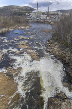
There are three falls, with the first being above an additional water diversion. Our day, it was bone dry, not a drop of water despite the river being at 3,810 cfs. I am not sure what the capacity is of that top bypass. That drop has been run, but is a long slide that pinches off into a cascade at the bottom. It looked big in its dry form. The second set of drops come back to back. The top one was a big slide that had some pothole and kickers in the middle of the main flow that I would want to scout at low flow before committing to. So we "snuck" down the far right small channel to avoid those features. We had hope to run a left to right line to avoid, but upon scouting from the island lip, we found too many shallow rocks at that flow that would prevent the move from being successful. Due to that, I would agree with the local, John Preebal, that was giving me some general info that 5,000 to 5,500 is likely the sweet-spot for being able to run main line. The bottom drop was the biggest and had a weird slide that ran directly into a massive kicker (too big to run). Off to the right was a two step shelf with two large holes. Apparently there is a far right line, we did not see it though. We opted to not run it as we would have had to scout thoroughly and were feeling lazy and not sure fired up on this cold windy day.
If they were successful in getting releases, I could imagine the bottom set becoming a nice park and huck location. The runout of the lower also had a lot of fun little moves that I could see being good for instruction. But we did not go down there to explore as Aster and Grandma were huddled in the car trying to keep warm.
For some low water photos of #2 and #3 Check out this link
For some photos of #1, check out this link and this link
Mi N/A:
- Falls #1 (V+). Apparently this one was run years ago. It was dry when we were there. It is a big slide and then drops into a pinch at the end. We didn't try hard to actually scout it since it was dry and we had Aster and Beth with us. I think downriver from the road, there was a turnout that you could get a good view of it all with binoculars. The "trail" that was supposedly (google) along the rapid was a private road and fenced off so we aborted trying any harder.
Falls #2 (IV to V). Another dam stands between #1 and #2/#3 and this is the one that correlates to the gauge. We needed more water I think to make the slide more fluid. The main channel drops through a few potholes and then hits a rock ledge and pillows off of it. I would like to see these potholes and the rock ledge at low water to understand them to consider running down middle through them. We had hoped we could run center driving right to avoid the potholes but there were guard rocks preventing the move from occurring that needed just a one or two more inches of water. So, we ran down the right sneak entrance which then renters the main flow below the last kicker in the middle and drops you through the hole. At high flow I can imagine center lines or even left of center lines opening up and being big and fluffy like Quebec. Do note, that the bigger Falls #3 is immediately downstream like 100 ft.
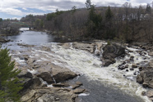
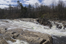
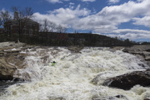
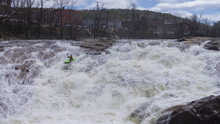
Falls #3 (V to V+). We did not scout it thoroughly. But it looked like the main lines were all too sticky to think about. Apparently, there is a sneak on the right shore around the fluff. The main line is a slide then melts off to the right into a pair of sticky ledge holes back to back. Or slides straight into a big big kicker that looked too big to run. Or melts left into another pinched caldron that looked no good from above. I think there may have been a super thin mainline down the slide and avoid the kicker by inches to the right which then would sale you over the corner of the two step drop. It was thin. It may go. We didn't want to spend the time to sort it out though.
Access #1: Boivin Park looks like a good option though I do not know if you can get to the water there. It is on Bridge St just above the lower dam. So you would paddle across the lake to the base of the drop and find a way to walk up it. The other access would be from the bridge on S Rumford Rd, the eastern side has a dirt road but it is gated and off the river, so I am unsure if you can get down to the water there as well.
Access #2 and #3: At the corner of River St and Portland St, on the south side of Portland St, is a parking lot to access these drops.
HTML Comment Box is loading comments...
